Trail
Izvoru Muntelui – Cabana Dochia
The route from Izvoru Muntelui to Cabana Dochia is the eastern gateway into the Ceahlău massif: a sustained climb through forest onto the alpine plateau, where Cabana Dochia becomes the base for outings to Toaca Peak and the rest of the plateau. It is a moderate, classic and heavily used trail — a good first day on Ceahlău.
Figures are approximate: roughly 3 hours of climbing, +~900 m of gain, waymarked with a blue stripe. Real time depends on your pace and the weather — in rain the path turns slippery, so plan for more.
On the trail
You start at Izvoru Muntelui (~800 m), near the Bicaz dam and the end of the forest road, following the blue stripe westwards, uphill.
- Start (Izvoru Muntelui). Pick up the blue stripe. The beginning is gentle, then the slope rises steadily through dense spruce forest.
- The forest climb. The longest part of the route — a shady path with natural steps of roots and stone. It is usually cool here even in summer, but also muddy after rain.
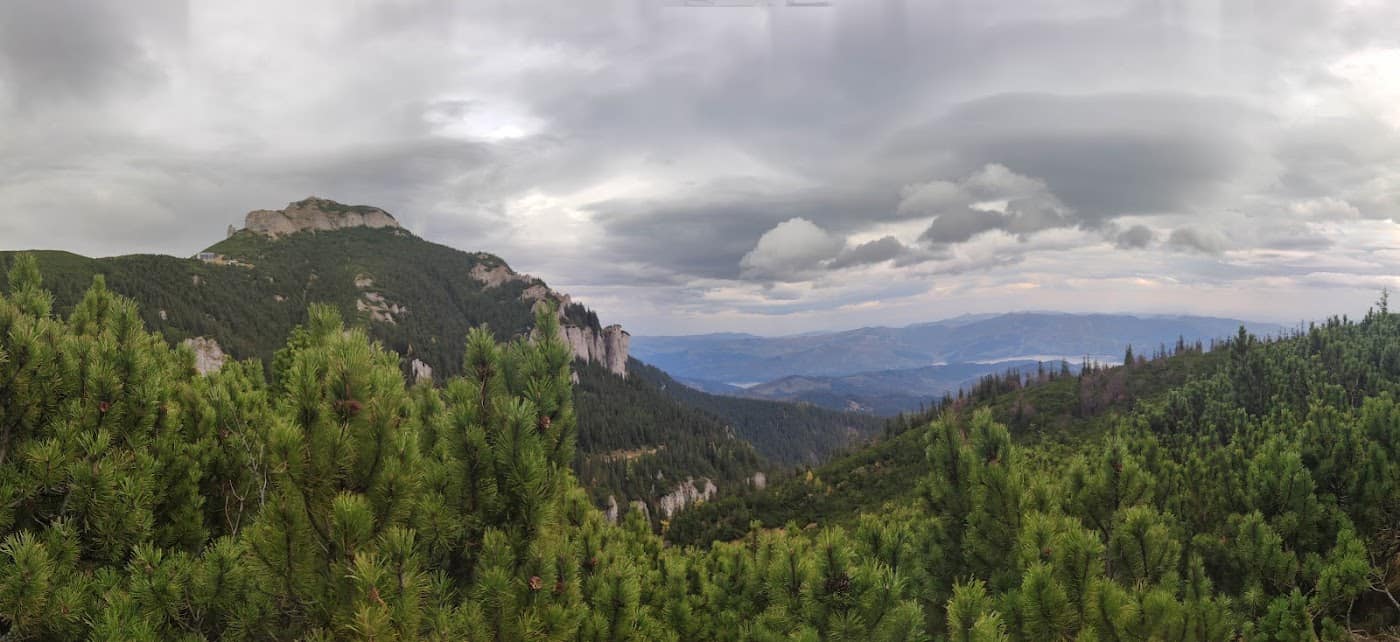
- Out towards the plateau. The forest thins and the first views open over the Bistrița valley and Lake Izvorul Muntelui. The terrain opens onto the alpine meadows.
- The Ceahlău plateau. Once on the plateau the landscape becomes wide and wind-exposed. You follow the marking towards Cabana Dochia.
- Cabana Dochia (~1750 m). End of the stage: shelter, a place to rest and the base for the push to Toaca. It usually operates in season; check hours and lodging locally.
From Dochia you can continue to Toaca Peak up the metal stairways, or descend towards Durău. The area lies within Ceahlău National Park, in the Ceahlău–Bicaz region.
Equipment and difficulty
Difficulty is moderate — a long, steady climb but no technical sections up to the cabin.
- Mountain boots with good grip (the forest path is slippery when wet).
- Thermal layer and a hardshell — the plateau is windy and cold even in summer, even though you climb through forest.
- Water (2 l), snacks; do not rely on dependable water sources along the way.
- Map / GPS for fog on the plateau.
See the equipment guide for details.
Safety
Up to the forest edge the trail is sheltered; on the plateau the altitude hazards appear:
- Fog — on the open plateau you lose your bearings fast; follow the blue stripe and carry navigation tools.
- Sudden wind and cold — the contrast with the forest can be sharp; keep an extra layer to hand.
- Lightning — the plateau is exposed; in a storm retreat into the forest and do not step into the open.
Retreat option: if the weather turns on the plateau, Cabana Dochia is the nearest shelter; otherwise you can descend the same trail, safer than continuing exposed. Turn back in good time and do not push on in thick fog. Check the weather and the safety guide.
Emergencies: 112 (Mountain Rescue / Salvamont).
⚠ Indicative trail data. Mountain weather changes fast — check the forecast, markings and conditions before you set off. Tell someone your route.
Trail map
Indicative topographic map (OpenTopoMap) — it shows the terrain and the marked paths. Download the route offline and don't rely on signal on the ridge.
Plan your trip
Everything you need for the mountains
Affiliate content: bookings through these offers may earn us a commission, at no extra cost to you.
Stays in the area
Stays nearby
Compare stays available near this place, on the map.
Accommodation map by Stay22 · indicative prices. Bookings through the map may earn a commission, at no extra cost to you.
Frequently asked questions about the Izvoru Muntelui – Cabana Dochia trail
How long does the Izvoru Muntelui – Cabana Dochia trail take?
The stated duration is indicative and depends on your pace, breaks and the weather. Start early and leave enough time to return before dark.
What gear do I need?
Grippy boots, clothing layers, a rain shell, water, food, an offline map/app and a head torch. At altitude, pack a warm layer even in summer.
Is the Izvoru Muntelui – Cabana Dochia trail safe?
With preparation and good weather, yes. Check the forecast, tell someone your route, turn back if the weather worsens and save the emergency number 112 (mountain rescue). Ridge routes require experience.